Coober Pedy
I had grown fond of Alice Springs - and the entire Northern Territory - but the journey had to move forward.
Uluru, The West Mac's and Kata Tjuta, all left me with very exciting tales and memories, and I sure could have stayed much longer. But at the same time, I was eager for my next destination, the unknown, the mysterious opal mining town of Coober Pedy, SA.
The days were getting hotter and drier, and the thought of trekking 900Km across the desert with no water supplies along the way was less than appealing. South of Alice was met by flat, dry, plains. Rock and sand. Straight up desert.
While my time in C.P. was short, it was filled with fascinating encounters and events. Before arriving, I never would have thought I would find myself standing in the home and mines off the late Crocodile Harry - which was featured in Mad Max III: Beyond Thunderdome.
Two themes developed very quickly out there; 1. Opal mining - obviously; and 2. Film. Many well known (and some not so well known) films have been shot - at least in part, out in the areas surrounding Coober Pedy. Mad Max III, Priscilla Queen of the Desert, Pitch Black and Red Planet to name only a few, were all filmed quite close to the Aussie mining town. And I had the chance to stand "on location" where these films were shot. I even stood beside one of the shuttles from Pitch Black!
This town is mining, lain and simple. The opal drive still continues today, similar to how it did back in the beginning days - when a school boy on holidays could easily get swept up in the excitement and commotion and find himself some 40 years later still meaning to return home at some point. I kid you not. That was the reality for many of these guys, including my host, tour guide and life long miner "Uncle Jimmy", who arrived to Coober Pedy on a week-long school holiday trip, and decided three month later to call his parents to let them know he was staying put. Caught up in the hustle and bustle and the excitement that captured many hearts, as well as many lives.
Most opal mines in these areas are privately owned, and most mining is still commenced with hand operated equipment, burrowing through the ground. Anyone can get a permit to mine, you simply need to apply for a permit and your site pegs and away you go from what it looked like.
I tried my hand at "noodling" a few times - picking through piles of dirt and rock in search of opals - with what I though to be a decent amount of success. Mind you I sure didn't strike my fortune, but I walked away with a few nice shinny bits.
Since he entire town is situated in the middle of a desert, daytime temperatures can reach excruciating highs of up to 50°C. It is for this reason the the town is mainly built underground. The streets and main floors of many buildings sit above ground, but where typically buildings would be built upwards into the air, in Coober Pedy, the buildings recede into the ground - or are built by hollowing out side hills - allowing cooling of the buildings to be much easier, and offering considerable more protection from the elements. Our hostel for instance, was built like this. My room was located roughly 16' underground. It was very cool... No pun intended.
It is quite true that no visit to Coober Pedy is complete without stopping by John's Pizza Bar. I highly recommend the Emu pizza.
Tuesday, February 14, 2012
Wednesday, December 28, 2011
Ranger Tactical XTA-SURVIVOR 1 survival kit - Review
Ranger Tactical XTA-SURVIVOR 1 survival kit
You never know when a good situation can turn bad. But when it does you need to be prepared.
The Ranger Tactical XTA-SURVIVOR 1 survival kit offers all the essentials to help ensure survival if things do turn for the worst.
Includes: - Jets Sream Whistle
- Arctic Emergency Blanket
- 37-piece 1st aid kit
- Starflash Signal mirror
- Compass
- "Strikeforce" all weather fire starter w/"Wetfire" tinder
Contents are packed into a "Mil-Spec HD heavy duty military grade belt pouch". The pouch is versitile, and able to be worn horizontally or vertically, meaning you can place it exactly where you need it with no hassle.
While trekking across the outback I often found myself straying far from camp, and getting into some pretty sticky and intense situations, especially during rock climbing and tricky ascents in the West MacDonnell Ranges of the Northern Territory. I made sure to always have my kit on hand - some days, carrying it alone.
With some careful packing the pouch will also hold a standard 500ml water bottle - an absolute necessity when setting foot away from camp out there - which can allow you to get away with not carrying a full pack when you really want to get away from it all.
 (Left) The kit I never left camp without. Knives and flashlight not included in kit, but all available from Ranger Tactical.
I also added a medium carabiner to the pouch for fast and easy access on and off of my belt or pack.
The pouch is still holding up strong eight months later, after taking quite a beating. Excellent abrasion resistance and high capacity in a kit that won't get in your way.
Thanks to Peter and Julie at Ranger Tactical for setting me up with this little lifesaver.
Check out this, and many other Survival kits and tools at www.rangertactical.com
You never know when a good situation can turn bad. But when it does you need to be prepared.
The Ranger Tactical XTA-SURVIVOR 1 survival kit offers all the essentials to help ensure survival if things do turn for the worst.
Includes: - Jets Sream Whistle
- Arctic Emergency Blanket
- 37-piece 1st aid kit
- Starflash Signal mirror
- Compass
- "Strikeforce" all weather fire starter w/"Wetfire" tinder
Contents are packed into a "Mil-Spec HD heavy duty military grade belt pouch". The pouch is versitile, and able to be worn horizontally or vertically, meaning you can place it exactly where you need it with no hassle.
While trekking across the outback I often found myself straying far from camp, and getting into some pretty sticky and intense situations, especially during rock climbing and tricky ascents in the West MacDonnell Ranges of the Northern Territory. I made sure to always have my kit on hand - some days, carrying it alone.
With some careful packing the pouch will also hold a standard 500ml water bottle - an absolute necessity when setting foot away from camp out there - which can allow you to get away with not carrying a full pack when you really want to get away from it all.

I also added a medium carabiner to the pouch for fast and easy access on and off of my belt or pack.
The pouch is still holding up strong eight months later, after taking quite a beating. Excellent abrasion resistance and high capacity in a kit that won't get in your way.
Thanks to Peter and Julie at Ranger Tactical for setting me up with this little lifesaver.
Check out this, and many other Survival kits and tools at www.rangertactical.com
Tuesday, December 20, 2011
Larapinta pt. 2
Its been quite some time since I have properly updated you all on the journey. We left off at my departure into the West MacDonnell Mountain Ranges of the Norther Territory, north of Alice Springs. Although my original intention was to walk you day-by-day along my trek there, it doesn't seem to do justice to just how incredible the trek really was.
I would safely label that time as my life's biggest "You had to be there" moment.
With the Larapinta Trail as my guide I was gone 'walkabout' across some of the most amazing country I have ever seen.
I was over a week in the mountains, tackling 200km of mountains and valleys, gorges and river-flat plains, headed west towards the Tanami desert.
In a situation like this, proper water consumption should be priority (right up there with NOT getting bitten by snakes). On only day 2 of my trek I felt the effects of dehydration and heat stroke - only 49Km in. Not cool. I saw first hand just how easy it is to fall victim to dehydration, one of the leading causes of death in the Outback.
Drink little and drink often. Drinking too much water can be damaging just as under drinking can be. You can't afford to forget to drink enough in a situation like that. 28-32 degree days, a lot of ascent, and day after day of beating sun while you are constantly on the move.
My best bet would have been walking at night by the light of the moon. The skies were so clear that even a half moon would have given ample light to walk by, not to mention I was carrying so hefty fire power for lighting. But instead I kept to the light, waking early before sunrise and setting up my nights camp in the fading evening light. I made camp each day in the hottest hours of the afternoon. I would set up my tent and do my best to create at least some shade, which wasn't always easy.
One afternoon I stopped to make camp on a high ridge spanning mountain peaks, there were no trees, and almost no bush or scrub of any kind thanks to the bush fires. And with the sun directly overhead its hard to make any escape.
The only real shelter at that point was to pitch my tent - which was no cup of tea in the wind at 1100' on a 5m wide ridge - and use my sleeping bag to line the roof of the tent in order to cast at least a bit of shade to get myself out of direct sunlight. This method was pretty effective, however it doesn't compare to the shade of a nice big river gum. The down insulation held the heat in more than I would have liked, but it was good to get out of the sun!
 My biggest concern throughout the trek, and across the whole country really, was mainly the snakes. And considering there are some 140 different species of land snakes in Australia, not to mention about another 32 water snakes, the odds of running into one in some of the places I went was a given. And boy I saw a lot. I was averaging 3 snakes a day in the mountains. Mainly browns(like the one to the left) thankfully. Though I did encounter one smaller python and what I believe may have been a small fierce snake - the most toxic species of land snake known to man. However, it is NOT the worlds most toxic venomous snake.
I was actually fairly impressed at how much surface water there was to be found across the West Mac's. Now mind you, a large portion of it was far from drinkable, however I did find a few water holes suitable for a refreshing swim, and apparently drinkable too! But there was a lot of tainted water out there, mucky, slime filled, orange-green-brown sludge pools. And at one point I thought I had found a nice little pool, possibly something I could filter and store for boiling, coming from an underground spring in the rocks at that. But... I am glad I took my time to check out the scene before I dove in. See the below picture.
Warning... the following images may make you squirmy and icky...


Yup, a kangaroo carcass had spoiled the waterhole.
This is something you need to be extremely careful about when searching for water. You can't be too careful when scouting the source of you water, making sure you aren't drinking from a stale source. But you must also be sure to inspect the area AROUND the water. Even though the majority of the roo was not in the water, it lay on a ledge above the water, and you can bet your boomerang there has been more than enough wash in to that pool to taint the water beyond salvage. On top of that, a skull in my drinking water is enough to turn me off as it is.
But these weren't the only "left-overs" I found around Oz; camels, cows, wild pigs, roos, wild goats. The camel bones looked like dinosaur bones, an exciting find out in the mountains.


I would safely label that time as my life's biggest "You had to be there" moment.
With the Larapinta Trail as my guide I was gone 'walkabout' across some of the most amazing country I have ever seen.
I was over a week in the mountains, tackling 200km of mountains and valleys, gorges and river-flat plains, headed west towards the Tanami desert.
In a situation like this, proper water consumption should be priority (right up there with NOT getting bitten by snakes). On only day 2 of my trek I felt the effects of dehydration and heat stroke - only 49Km in. Not cool. I saw first hand just how easy it is to fall victim to dehydration, one of the leading causes of death in the Outback.
Drink little and drink often. Drinking too much water can be damaging just as under drinking can be. You can't afford to forget to drink enough in a situation like that. 28-32 degree days, a lot of ascent, and day after day of beating sun while you are constantly on the move.
My best bet would have been walking at night by the light of the moon. The skies were so clear that even a half moon would have given ample light to walk by, not to mention I was carrying so hefty fire power for lighting. But instead I kept to the light, waking early before sunrise and setting up my nights camp in the fading evening light. I made camp each day in the hottest hours of the afternoon. I would set up my tent and do my best to create at least some shade, which wasn't always easy.

One afternoon I stopped to make camp on a high ridge spanning mountain peaks, there were no trees, and almost no bush or scrub of any kind thanks to the bush fires. And with the sun directly overhead its hard to make any escape.
The only real shelter at that point was to pitch my tent - which was no cup of tea in the wind at 1100' on a 5m wide ridge - and use my sleeping bag to line the roof of the tent in order to cast at least a bit of shade to get myself out of direct sunlight. This method was pretty effective, however it doesn't compare to the shade of a nice big river gum. The down insulation held the heat in more than I would have liked, but it was good to get out of the sun!
 My biggest concern throughout the trek, and across the whole country really, was mainly the snakes. And considering there are some 140 different species of land snakes in Australia, not to mention about another 32 water snakes, the odds of running into one in some of the places I went was a given. And boy I saw a lot. I was averaging 3 snakes a day in the mountains. Mainly browns(like the one to the left) thankfully. Though I did encounter one smaller python and what I believe may have been a small fierce snake - the most toxic species of land snake known to man. However, it is NOT the worlds most toxic venomous snake.
I was actually fairly impressed at how much surface water there was to be found across the West Mac's. Now mind you, a large portion of it was far from drinkable, however I did find a few water holes suitable for a refreshing swim, and apparently drinkable too! But there was a lot of tainted water out there, mucky, slime filled, orange-green-brown sludge pools. And at one point I thought I had found a nice little pool, possibly something I could filter and store for boiling, coming from an underground spring in the rocks at that. But... I am glad I took my time to check out the scene before I dove in. See the below picture.
Warning... the following images may make you squirmy and icky...


Yup, a kangaroo carcass had spoiled the waterhole.
This is something you need to be extremely careful about when searching for water. You can't be too careful when scouting the source of you water, making sure you aren't drinking from a stale source. But you must also be sure to inspect the area AROUND the water. Even though the majority of the roo was not in the water, it lay on a ledge above the water, and you can bet your boomerang there has been more than enough wash in to that pool to taint the water beyond salvage. On top of that, a skull in my drinking water is enough to turn me off as it is.
But these weren't the only "left-overs" I found around Oz; camels, cows, wild pigs, roos, wild goats. The camel bones looked like dinosaur bones, an exciting find out in the mountains.

My gear held up well, and I was more than impressed, especially with the performance of my shoes. I definitely stretched the capabilities and boundaries of my Ospray Atmos 50L pack though. Between my 5L of water, food rations and my gear I well exceeded the recommended weight to be carried in it - avg. 35Lbs. But it held together. I did feel the repercussions, and they weren't pretty, but it was one heck of a pounding test for it. That bag has been dropped, dragged, banged, tossed and everything in between and she still holds tough. Can't beat it.

Saturday, November 5, 2011
Larapinta pt. 1
Light smoke still lingered in the distance surrounding Alice Springs on the morning I set out for the Larapinta Trail.
I left just before first light, crossing town and making my way up the dry river bank to the trail head. My starting point was the old Alice Telegraph station, several Km north of town.

It was light by the time I reached the trail head. It was also very cool, but by that point I was used to the cool Aussie mornings. My goal for the day was to complete the near 24Km first section of the trail as far as Simpsons Gap.
I'll be honest, I really had no idea what to expect setting out. I was in for the long haul. Set to travel light. Set to travel fast. Leaving behind the majority of my gear, including my camp stove and water filter, I was traveling with more weight in water and emergency rations than gear! Not quite what I expected "light" to feel like.
Climbing out of the river banks, I set up across the rocky hillside, entering the West MacDonnell Mountain Ranges.
I remember thinking after the first two Km or so, "If it's all like this, I'll be out and back in no time." But I quickly found out that it definitely was not going to be that easy. The beginning of the trail is somewhat deceiving compared to what lay several Km in. But this hasn't been ranked as one of the worlds premier hiking trails for nothing. In fact, I had no idea what lay in store for me... not at all.
I would definitely urge anyone interested in hiking this tail to obtain a copy of the trail info pack (available online and at the Info Center in Alice Springs), and study it well. I had a copy. I glanced at it the night before setting out, read a few of the pointers they outlined, and tucked it away. I figured I would wing it for the most part. The trail was marked out... sort of. I had my bearing... West... ish. After all, whats adventure without a little surprise?
 I had decided to pull up and make camp on the first day for lunch and a short rest at Wallaby Gap, about 13Km in. The hike to Wallaby Gap after crossing the Stuart Highway (what I considered to be my real entry into the wild from Alice) had been a constant slow ascent until reaching the base of Euro Ridge. It was quite a climb to the peak, where I had a great view of Alice Springs and the surrounding desert and mountains. What a view. Sitting with my feet dangling over the 750m cliff, I tried to work out where the path on the next ridge would lead down to my next rest point, and lunch! At Wallaby Gap.
From there the terrain flattened out a bit more, and it was smooth sailing for the next few Km before the push to reach Saddle Hill Hat. The ridge marked the final stretch of the day, with a gradual descent to Simpsons Gap.
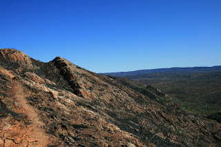
 The effects of the wildfires which had torn through the ranges were wide spread in every direction. But rather than just one constant strip of scorched hillside, what I experienced was huge patches of burnt area, followed by several hundred yards of fresh green growth, then more burn area. It definitely made for an interesting trek. Lots of areas (like the one shown in the picture to the left) are covered in chard shrubs shooting out of a bed of white ash, which completely covered the ground in areas.
I was exhausted when I reached the gap, dehydrated and ready for a solid nights rest. I knew I hadn't drank nearly enough water over the day, in fact no where near enough.
Until this point The Outback and I had been on fairly even ground, I had handled the terrain and changing elements well. But the West MacDonnells were quickly shaping up to be a whole new ball game. My toughest challenge yet? You bet ya! I hadn't felt this out of shape the whole trip, and considering it was only the end of day, it was seeming as though it was going to be quite a battle.

Sunset over the Gap that night was certainly a spectacle to behold. Similar to Uluru, the Ranges here turn amazing colours as the sun sets.
I bunked in as the sun went down to look over the next days route and see what lay in store. I'd be looking to make at least 25Km before sunset. The majority of the day would be ascent, with the exception of the last 3Km, descending to where I'd hope to make camp for the night.
I left just before first light, crossing town and making my way up the dry river bank to the trail head. My starting point was the old Alice Telegraph station, several Km north of town.

It was light by the time I reached the trail head. It was also very cool, but by that point I was used to the cool Aussie mornings. My goal for the day was to complete the near 24Km first section of the trail as far as Simpsons Gap.
I'll be honest, I really had no idea what to expect setting out. I was in for the long haul. Set to travel light. Set to travel fast. Leaving behind the majority of my gear, including my camp stove and water filter, I was traveling with more weight in water and emergency rations than gear! Not quite what I expected "light" to feel like.
Climbing out of the river banks, I set up across the rocky hillside, entering the West MacDonnell Mountain Ranges.
I remember thinking after the first two Km or so, "If it's all like this, I'll be out and back in no time." But I quickly found out that it definitely was not going to be that easy. The beginning of the trail is somewhat deceiving compared to what lay several Km in. But this hasn't been ranked as one of the worlds premier hiking trails for nothing. In fact, I had no idea what lay in store for me... not at all.
I would definitely urge anyone interested in hiking this tail to obtain a copy of the trail info pack (available online and at the Info Center in Alice Springs), and study it well. I had a copy. I glanced at it the night before setting out, read a few of the pointers they outlined, and tucked it away. I figured I would wing it for the most part. The trail was marked out... sort of. I had my bearing... West... ish. After all, whats adventure without a little surprise?
 I had decided to pull up and make camp on the first day for lunch and a short rest at Wallaby Gap, about 13Km in. The hike to Wallaby Gap after crossing the Stuart Highway (what I considered to be my real entry into the wild from Alice) had been a constant slow ascent until reaching the base of Euro Ridge. It was quite a climb to the peak, where I had a great view of Alice Springs and the surrounding desert and mountains. What a view. Sitting with my feet dangling over the 750m cliff, I tried to work out where the path on the next ridge would lead down to my next rest point, and lunch! At Wallaby Gap.
From there the terrain flattened out a bit more, and it was smooth sailing for the next few Km before the push to reach Saddle Hill Hat. The ridge marked the final stretch of the day, with a gradual descent to Simpsons Gap.
 The effects of the wildfires which had torn through the ranges were wide spread in every direction. But rather than just one constant strip of scorched hillside, what I experienced was huge patches of burnt area, followed by several hundred yards of fresh green growth, then more burn area. It definitely made for an interesting trek. Lots of areas (like the one shown in the picture to the left) are covered in chard shrubs shooting out of a bed of white ash, which completely covered the ground in areas.
 I was exhausted when I reached the gap, dehydrated and ready for a solid nights rest. I knew I hadn't drank nearly enough water over the day, in fact no where near enough.
Until this point The Outback and I had been on fairly even ground, I had handled the terrain and changing elements well. But the West MacDonnells were quickly shaping up to be a whole new ball game. My toughest challenge yet? You bet ya! I hadn't felt this out of shape the whole trip, and considering it was only the end of day, it was seeming as though it was going to be quite a battle.

Sunset over the Gap that night was certainly a spectacle to behold. Similar to Uluru, the Ranges here turn amazing colours as the sun sets.
I bunked in as the sun went down to look over the next days route and see what lay in store. I'd be looking to make at least 25Km before sunset. The majority of the day would be ascent, with the exception of the last 3Km, descending to where I'd hope to make camp for the night.
Saturday, October 15, 2011
Kings Canyon - Kata Tjuta - Uluru pt. 3
Uluru
Our first real taste of Uluru - more commonly known to the western world as Ayers Rock - began with a visit to the Uluru - Kata Tjuta Cultural Centre, owned and run by the Anangu people. These aboriginal peoples are known as the keepers, or owners, of Uluru, and they are very happy and keen to share their knowledge and history with visitors.
After our self guided tour through the visitors centre, where we learned about the history of the aboriginals who inhabited the area, as well as their Dreamtime stories and significances of Uluru in their culture, it was time to get up close and personal with the famous monolith.
As it was already pretty late in the afternoon by the time we reach the base of Uluru. We were guided along one of short tracks called the Mala Walk, which features many old aboriginal sites and rock art.
Now, scientists and geologists have many explanations and theories describing and unfolding the mysteries behind Uluru, Kata Tjuta and Kings Canyon. But the aboriginals have their own explanations for all of these things. And I have to admit, I think I like the aboriginals explanations better.
Rather than talking about erosion and sediment and fluvial channels, the aboriginals have ancient stories from the "Dreamtime" that explain every significance in the area. Every rock form, crevasse, cave and green space has a significance and a story explaining its creation and being.
 After our walk wrapped up, we headed for a lookout to grab a prime spot to watch the world famous Uluru Sunset! It is quite spectacular to watch the rock change colour as the sun sets. Such drastic changes in such a short period of time. It is quite a sight to see.
We spent the better part of the evening at the lookout, till well after dark. The full moon provided some very interesting photo opportunities. And while all of the other tour groups had arrived right at sunset and left instantly after, our crew arrived early to grab a prime spot, watched the entire sunset, ate dinner and stuck around much, much longer than anyone else. I almost feel sorry for the other people for missing out... Almost.
Finally we packed up and headed to make camp. It wouldn't be a long night, as we were waking in the wee ours of the morning to once again snag our prime spot for the sunrise view.
The nights were pretty cool, but not like many of the nights I had spent in Queensland - the coldest I was aware of had reached -5C. So these nights around Uluru were refreshing for me. But with a big fire rolling we all curled around with our swag and before we knew it, everyone was fast asleep except for myself and new friend Boris. Being our last night on the trip, and with such a large pile of firewood remaining we felt it was only right, our duty, to stay up and finish off the wood pile.

Morning has never come so early...
It was right up and at 'em the last morning of our trip. If I had checked the time I would say it had been around 4:30am. We rolled up our swags and had camped packed up surprisingly quick considering he hour of the morning.
It was great to spend those few nights out in the swags, not too, too cold, clear star-lit sky's and not a bug in sight. Though we were kept company by what I would have considered a small heard of aussie kangaroo mice. They were quite friendly little buggers.
So off we set for our lookout to watch the sunrise over Uluru - where we would also be having breakfast, and very much needed coffee. It was quite an experience all-in-all, and I have to give props to The Rock Tour for putting together such a well structured agenda.
Sunrise was nothing short of spectacular. Cameras went off like mad, here there and everywhere. And for a moment, I think everyone even forgot that they could see their own breath.
Once the sun had risen, we set off back to the base of the rock. We had the morning free to explore and wander some of the tails surrounding Uluru independently. This was our first chance to really get up and close for a little one-on-one time with one of Australia's oldest and most significant pieces of the countries culture and history.
Myself, and several others completed the entire base walk around the rock. The roughly 10Km loop is definitely the best way to take it all in here. There is so much to take in if a person is willing to open their eyes and their imaginations. Despite all the geological significances, it was the stories and the history of the aboriginals that caught me more than anything.
As I have said before, everyone experiences these place differently. Ten people visiting these places together can walk away in the end having had ten very different experiences. That is one of the beauties I discovered out here, but not just in the park, but the entire Outback. It holds something different for everyone. But little did I know just what the Outback had in store for me next...
Though one thing several of us did share was an encounter with two dingoes as we were walking the trail. They were so tame and in such good health that we mistook them for domestic dogs that had gotten loose from their owner. A bit father down the tail we discovered what we believed to be these dingoes den. Someone was certainly living there!

Wednesday, October 5, 2011
Kings Canyon - Kata Tjuta - Uluru pt. 2
Kata Tjuta
Our second stop on the three part trip took us into Uluru - Kata Tjuta National Park to Kata Tjuta.
The English translation of Kata Tjuta from the Aboriginal language means "Many Heads". The aboriginals were very straight forward in the naming process, and for the most part called things as they saw them. Kata Tjuta is a large rock formation spanning nearly 22 square Km and does in fact look like several heads poking out of the ground. Also referredto as The Olgas, named after Mount Olga, the sites highest point.
It was still dark as we started packing up camp that morning. Orion's Belt as clear as day in the north eastern sky. It felt like I had barely even gotten my eyes closed when we were all woken by the crackling fire and the smell of coffee catching everyone's attention.
Several cups of coffee later we had camp pretty well cleared and were ready to make our way. Daylight was just coming on as we headed off.
It was an incredible sight to see as we approached The Olgas, jetting out of the ground, these massive rock domes towered over the landscape. Our trek began through the Valley of the Winds, passing between huge rock faces. Several of us commented on what an awesome climb it would be going up any part of the rocks. But, climbing is forbidden at this site, and it is strongly reinforced. Regardless, I was more than satisfied with a look by the end.
 After we made our way through the entrance and into the center of the domes, the land opened up into lush (for the desert kind of lush), green rolling hills, with amazing rocky outcrops in the background. Everyone kept a sharp eye for snakes and any other critters we might spot as we wandered along the trail, through tall grass, under shade patches and over rocky terrain.
Now I don't know if it just me here, or if everyone gets sucked into the moment like I did here... again... But give me a whip, pistol and a cool hat and I would have felt like Indiana Jones diving in to yet another adventure.
Hmm... That happens a lot. I really need a cool hat.
You'll hear guides here talking about how places like Kata Tjuta and Uluru feel, and how everyone who visits may feel something different or significant. They are certainly right.
While I did hear some people comment on how they felt nothing at all around any of these ares, I know I sure did. What exactly it was, I'm not sure. But for those of us that did we all knew it, and though we couldn't really explain it we understood at least that we each knew it was there. Personally, and this comes not just from this outing, but my entire experience out here, it seems as though too many people spend their lives watching, and never spend any time looking at/for, or feeling what is around them. I was asked several times on our trip why I was so good at spotting animals and tracks, and I would just answer that I was looking for it.
The way the caverns closed in around certain areas definitely made it feel as though you were being watched I found. Dozens of small caves fill the rock walls all over the place. Even the rocks on the ground seemed to be watching you!

Seeing these places with a guided tour like ours really is the best way to spend your first experience. There is so much culture and history to the areas which otherwise would go unknown to the lone traveler. The aboriginals have a meaning and significance for everything. The rivers, the rocks, forests. And not just the items themselves, but their shape, markings, colour... It all has a purpose, a meaning. And to discover that so many people still share a connection to this meaning, the Dreamtime and the culture was, for me, quite pleasing and relieving to find out.
We didn't encounter too many critters on this trek, however, just before returning to the parking lot to make our way out I spotted a small lizard crouched in the rocks along the side of the trail. He was a little skittish at first, but warmed up to me quite quickly!
Soon after, we hit the dirt again and set off for a quick lunch before getting our first taste of Uluru (Ayers Rock).
Monday, October 3, 2011
Kings Canyon - Kata Tjuta - Uluru pt. 1
Kings Canyon
I didn't waste any time in hitting the sights upon arriving in Alice Springs.
I had found out while still in Darwin that half of the Larapinta Trail - which I was intending to begin hiking right away on arriving in Alice Springs - had be burnt right out and was still at high risk of wildfires. By the time I arrived in Alice things hadn't changed.
So rather than sit around and wait for the tides to turn on the trail I decided it was time to see some sights and jumped in on a guided Camping tour to Uluru (Ayers Rock), Kings Canyon and Kata Tjuta (The Olgas).
The trip started off with a bang. The morning we were due to leave there was a huge thunder storm which was responsible for starting several fires in and around Alice Springs. Luckily things cleared up as we pulled away from town.
Because of the higher than average rainfall last year, more vegetation has grown across the and around the Red Center, creating high than average fuel for fires. And being the end of the dry season, things were DRY!
We passed miles and miles of blackened, scared land on the trip. Similar, I imagined, to what the Larapinta may look like at that moment.
 Kings Canyon was first on our agenda of amazing sights. And it was, in short, spectacular! We hiked to the top of the canyon and along the 'Rim Walk' across some amazing landscape, at times treading only inches from the over 300m high cliff's edge.
 Mid way around the canyon we descended into a valley known as The Garden of Eden. A tropical, lush forest leading to a permanent waterhole found deep in the valley. I was completely shocked when I found out I was the only person eager to dive into the waterhole. Such a peaceful, refreshing pool, on a hot active day, I wasn't saying no! So in I dove. I mean really, who wouldn't want to be able to say that they swam in the Garden of Eden? Apparently everyone but me? At least on that day.
Afterwords our trek continued back to the top of the canyon and across a long, dome-covered, sandstone plateau, where i spotted a giant Perentie sitting right beside our trail. I'm not sure how the rest of the group missed it, but this huge monitor lizard caught my eye instantly!
 While Perenties have been known to reach lengths exceeding 8 feet, our boy was roughly four and a half to five feet long. These guys are very similar to the Goulds Goanna which I encountered many of in Queensland, but are much slimmer and apparently to see one in the wild is quite rare, as they are known to be extremely timid and shy. However, this particular monitor couldn't have been happier to pose, basking in the sunshine as I snapped away all the photo's I could. This could probably be classed as another foolish situation where I got far too close to something. The claws and teeth alone on these guys is enough to do a person in, never mind the fact that scientists believe that Perenties may produce a venomous bite to top it off.
One highlight of the tour for me was the amount of knowledge our guide, Karmen, had about bush medicines and wild food. Karmen and i hit it off very early into the trip exchanging tips, stories and experiences in the outback. She was just as eager to hear about how the Canadian wilderness compared to Australia's as I was to learn all I could get out of her on Oz.
The view as we descended back to the bottom of the canyon was breath taking. It, and the whole area we had passed through reminded me of something out of an Indiana Jones movie, or The Mummy. Absolutely amazing country.
We pulled into camp that night just after dark. Our group seemed to all connect very well, very early on. Everyone pitched in and pulled their weight right from the get go, and in only minutes our camp was shaping up nicely. We had a nice big fire rolling, plenty of firewood for the night and the next morning (Following the 3:1 rule - Gather as much wood as you think you need for a night, then triple it), swags rolling out in all directions and dinner as on.
A night under the outback stars, sitting by the fire wasn't a new experience for me by this time - it felt like home. But there was something about being there with new friends, sharing new experiences (and tell tales of many of my past experiences as well) and just being in the moment that was very refreshing, and as exciting as your very first camping trip.
The outback has been very good to me. It has taken me a long way, in what I must admit has been a much safer manor than I had anticipated. For that I am very grateful. And even though I chose the path I did... alone... Aware of the potential danger and anticipation of loneliness, I don't regret the decision, though to be able to share part of that experience, even though only a small fraction, made it all worth while.
As we all tucked in that night after a mighty feast of mince chili and rice over the open fire, kangaroo mice bouncing rigorously throughout our campsite, and the milky way high over head, I couldn't wait to find out what the following days had in store.
Subscribe to:
Posts (Atom)